Google’s new platform to save forests from being destroyed
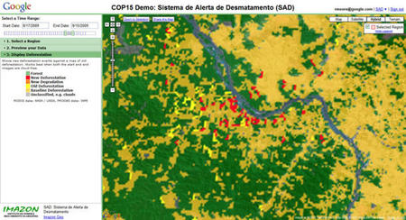
A high-performance satellite imagery-processing engine introduced by Google.org can be the future tool of detecting climatic changes! This handy tool enables people to check on the depletion of forests and the chopping down of trees. This platform was a joint effort with inputs from a professor of the Department of Global Ecology at the Carnegie Institution for Science and of the Department of Geological and Environmental Sciences at Stanford University, Greg Anser and a geologist at Imazon, Carlos Souza. It uses satellite imagery to check the changes in forests over a given period of time. If put into practice by the United Nations, the REDD (Reducing Emissions from Deforestation and Forest Degradation in Developing Countries) will need constant monitoring of forest and land use by the member nations. Google.org hopes that this application will help save the forests from being chopped down to make way for farm land or for the use of wood.
Google.org is currently testing this application and plans to release it on a wider scale in the near future, though it may not be for the common public and maybe restricted to be used only by scientists, governments and environment monitoring organizations. This application provides for the shortcomings of the much acclaimed Google Earth application and takes satellite imagery more seriously.
[Cnet]